Palo Alto Airport
This page is for people visiting KPAO, student pilots starting training here, and anyone interested in the local conventions.
Disclaimer: As you'd expect, this information is given as one pilot helping another for general orientation only, and in no way is intended to replace use of official charts and publications like the A/FD.
Rich Acuff has been flying out of Palo Alto Airport since 1992 and providing flight instruction there since 1998. If you find this page useful, please let me know!
Last updated May 2024.
Overview
KPAO sits beside San Francisco Bay, northeast of the city of Palo Alto. It boasts one 2,400' runway (plus a little overrun), and a heck of a lot of traffic. Most of the time winds favor runway 31, but runway 13 gets its share of use in the winter. The tower runs from 7am to 9pm mostly. And believe me, those controllers work for a living. Despite having only one fairly short runway, KPAO is home base for many Silicon Valley pilots, home to various maintenance shops, a convenient gateway to Bay Area visitors, and the place where many, many new pilots spread their wings for the first time
The cities near the airport are noise sensitive, so there are noise abatement procedures. They're described in detail with the departure and arrival procedures, but basically we need to be at or above 1,500' when south of highway 101 (the Bayshore Freeway), and make a 10º right turn after takeoff from runway 31.
By the way, keep in mind that many people in the Bay Area get confused about directions. "North" often means "towards San Francisco" and "South" means "towards San Jose", since many of the major roads are oriented that way, but San Francisco is really more west than north. I call this "logical" north. On this page, I'm using true north (as opposed to magnetic north or Logical north) as my reference for directions. Keep that in mind as you think about directions.

Click image to view full size
Airport Layout
Like many things about KPAO, the layout of the ramp is a bit unusual. There are 4 tiny little taxiways giving access to the runway. They are Alpha, Bravo, Charlie, and Echo. There are rumors another exit could be built and Delta is reserved for that. These connect to taxiway Zulu (the parallel taxiway). Zulu is connected to the ramp by stub taxiways called Yankee 1, Yankee 2, and Yankee 3. Most of the ramp is south of the runway, not beside the runway like at most airports.
There are 2 main parking areas. Rows Foxtrot through November slant off from Yankee running north-south. South of that rows Papa through Whiskey run east-west. Getting in and out of Victor and Whiskey can only be done at the west end of the row--the east end is closed off. What few hangars we have are on the west side. Way in the southwest corner are most of the businesses and flying clubs (see the bottom of AirNav's Palo Alto Airport page for a detailed list.) The little terminal building/airport office is on the east side.
The "spot" for helicopters is next to the terminal building and rarely an issue for fixed wing birds. Transient parking is mostly on row Uniform with parking for large planes next to the Terminal building. The self-serve fuel island is at the northeast corner of the hangars.
Arriving
If you don’t want to mess with a lot of ATC you can arrive from roughly east or roughly west.
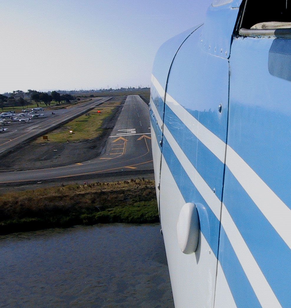
From the east, you will likely go through the Sunol gap, or pass just east of Reid Hillview Airport to avoid terrain. In either case, it is common to report to Palo Alto at or just before Leslie Salt (VPSLT). You'll want to be at about 1,500’. Most likely you’ll be instructed to, “make right traffic runway 31”. The problem is you probably won’t see the airport! What you will see is a turnstile for the railroad bridge in the middle of the bay. It is welded 90͒ to the tracks so it is easy to pick out. Fly towards it. As you get to it, you’ll see the runway on your left front and be able to easily turn to the 45 onto downwind at 800’.
From the west, you’ll use The Dish (VPDSH), a large dish-shaped radio telescope on a ridge, or SLAC (VPSLA), a 1 mile long building that passes under highway 280. Mostly you are told to “make left traffic runway 31”. That’s a bit tough because they want you to be above 1,500’ on the city side of highway 101, but the pattern is only 1,000’. The solution is to head to Cooley Landing (a small spit of land sticking out just south of the Dumbarton Bridge) and descend into the pattern as you are crossing 101. Normally descending into the pattern is bad, but there are no left crosswind departures, and left traffic is rarely used, so, with ATC’s help, it is pretty safe.
If you are coming from the Los Angeles area or other points southeast and are sharp with your radio procedures you can transition over KSJC and KNUQ. Navigate direct KRHV getting there at about 2,500’. Let ATC know you are planning “overhead San Jose”. As you get close to KRHV you will be handed off to KSJC Tower and instructed to “fly overhead the field at 2,000’”. After you pass KSJC they will tell you, “radar services terminated, keep the code, contact Moffet Tower…” Moffet will tell you to “fly overhead at or above 1,500’” Sometimes they instruct you to stay southwest of 101 (ie., away from the field). Usually as you are just about over the field they will pass you off to Palo Alto Tower who will have you “make straight-in runway 31”. If they are super busy you might get, “fly overhead at 1,500’ for pattern assignment.”
From the north, you can transition the SFO Class B or go over KOAK where you will end up mid-span of the San Mateo bridge at 1,400’ or below and will get a hand off to Palo Alto Tower.
IFR arrivals use the visual or the one and only approach, RNAV Rwy 31, which has only basic LNAV minimums; no glidepath. Note that this approach has a dogleg at the FAF, the final approach course isn’t aligned with the runway, and the descent angle from the FAF is steep. Be slow and ready to come down at the FAF. The runway is short, so you need to see it before the MAP if you are going to land; you don’t want to come in long and/or hot. NORCAL Approach almost always gives you “direct DOCAL” to start this approach.
If you have a WAAS-enabled Garmin you might see an LNAV+V approach and get vertical guidance. Keep in mind that this Garmin add on doesn't change the approach; you still cannot go below MDA, but your descent from the FAF might be a bit easier. Keep in mind that if the autopilot is following a glidepath it WILL NOT stop at a bugged altitude, and there are obstacles on the 34:1 plane at Palo Alto, so be careful.
If runway 13 is in use things change how you would expect. From the east “enter left base runway 13” is likely. Fly over the train bridge until you see the runway. From the west both, “enter right base runway 13” (fly towards Cooley Landing) and “make right traffic runway 13” are common. For right traffic, if you don’t see the airport, fly towards the amphitheater (large tent-like structure) until you get it in sight. From the south or north is the same except you’ll get instructions to enter the pattern from the south and might get “straight-in runway 13” from the north.

After Landing
The parallel taxiway, Zulu, is very close to the runway so there isn’t room to stop on the exit taxiways like at most other airports. Continue all the way off the runway and go forward a bit so there is room for another plane behind you before you stop to clean up and contact ground. Ground will give you something like, “taxi to transient via Zulu, Yankee 2, suggest Juliet, Uniform.”
Yankee 2 is one of 3 stub taxiways that connect Zulu to the ramp. Yankee 3 is most northwest and isn’t used much when runway 31 is active. Yankee 2 is in the middle and is the common exit point. Yankee 1 is close to the threshold and is used by departures.
Note that Palo Alto does not have standard taxiway signs. The only identification is painted on the taxiway surface, and can be a little hard to see in some lights. Don’t hesitate to ask for help from Ground.

The “suggest” part of the clearance is because the movement area (ie., the area ATC permission is required to use) ends on the Yankee 1, 2, and 3 taxiways, so ground isn’t really responsible for the rest of the ramp, but they like to help out and so suggest a route that will help keep you away from the outbound planes.
Juliet starts right at the end of Yankee 2 and runs south through most of the ramp, and you will use all of it because transient parking is just about as far as you can get from the runway. Juliet ends in front of a large hangar where you turn left about 45 degrees for a short distance and then 45 degrees more onto row Uniform for transient parking.
If runway 13 is being used your best bet is to roll to the end of the runway if it is convenient (and the runway is short enough it isn’t hard to do.) Usually the conditions that lead to 13 being used mean the airport isn’t busy, so you won’t be in anyone’s way and you will avoid being head to head with someone taxiing to the runway on Zulu. For transient parking, you are more likely to get, “taxi to transient via Zulu, Yankee 1, suggest Yankee, Uniform.” Yankee just takes you along the east side of the airport instead of the middle where Juliet runs.
Departure
Tell Ground how you want to depart on your initial call. You can also let them know if you want flight following somewhere.
All departures off 31 have a 10° right turn after lift-off for noise abatement. That is 318° if you are picky, or head for the western end of Cooley Landing.
The usual departures are:
Heading east use the Right Dumbarton. Fly upwind to the automobile bridge, then turn right and follow it across the bay. This departure keeps you away from the inbounds that funnel over Leslie Salt and out of the airspace to the north and south. Keep it under 3,000’ to stay out of the Class B until you are past highway 880.
Heading west use, you guessed it, the Left Dumbarton. Fly upwind to the automobile bridge, then turn left to cross highway 101 at 1,500’ or more. Because of the extended upwind, even slow climbers can do it.
Heading north ask for an Upwind departure and let Ground know your destination and they will help arrange your flight, be it a transition through the Class B, overflying KOAK, or a short hop to KSQL.
Heading south ask for a Left Downwind departure and tell Ground your destination. They will get you a squawk and departure frequency so Tower can hand you off to NORCAL Approach. Expect vectors and altitudes as they work you past KSJC then “resume own navigation.”
For IFR, your clearance is likely to contain, “...runway 31 obstacle departure procedure, San Jose [rest of route], climb and maintain 3,000’, expect [final alt] in 5 minutes…” The obstacle departure procedure is currently dead simple with a right turn and then direct SJC, but be sure to check it in case it changes.
Things are a bit different off runway 13.
Heading east, use the Leslie Salt departure where you turn your left crosswind a little further and fly to the salt piles. This helps keep you out of the low 1,500’ shelf of the SJC Class C as you climb.
Heading west, ask for a Left 270 Overhead. If you aren’t familiar, that means fly a normal left traffic pattern until approaching mid-field on downwind where you turn over the airport. The extra time climbing lets you cross highway 101 above 1,500’.
For north a Left Downwind works fine, but still let Ground coordinate for you.
For south you can usually get a Straight Out if Moffet isn’t busy as long as you get Ground to coordinate for you.
IFR is the same except the initial turn is to the left, but you are likely to wait a bit longer for takeoff if KSJC is landing 12.

Getting to the Runway
Call Ground from your parking spot. In addition to the usual stuff, let them know what departure you want and, optionally, if you would like flight following somewhere. An example call might be, “Palo Alto Ground, Cessna 1234, transient parking, request taxi Right Dumbarton and flight following Modesto, with India.”
Ground will likely respond with something like, “Runway 31 suggest Yankee, taxi Yankee 1, Zulu, advise runup complete.” They are recommending you use taxiway Yankee to get to the run-up area but since that is a non-movement area it is not an instruction. That makes sense because you enter the run-up area off Yankee from the south and proceed to the furthest T-spot you can reach. Be careful of the fence on the right side.
Note that the controllers are usually pretty picky about wanting to hear the runway and assigned taxiways in your readbacks.

Note you have already been given permission to taxi on Yankee 1 and Zulu, but you won’t actually use that permission until you contact Tower. Basically, Ground is saving Tower from having to say that. The, “taxi Yankee 1, Zulu, advise runup complete” does make the instructions sound way more complicated if you aren’t ready for it. The call from Ground does vary so that sometimes they don't include Yankee 1 or Zulu, sometimes they include "advise runup complete", but you pretty much always do the same thing.
Once your run-up is finished, you tell Ground “run-up complete” and they respond, “hold short of Yankee 1, contact tower”. You taxi straight ahead onto Yankee and few feet over to just short of Yankee 1 and switch to Tower. Tell Tower “ready for departure” and you will generally get one of, “hold position”, “hold short of runway 31”, or “cleared for takeoff”.
If you are IFR, your initial call is just “taxi, IFR [destination], with [ATIS].” Ground will give you your clearance in the run-up area. When you call Ground with “run-up complete” they will tell you to “hold position, contact tower.” By keeping you in the run-up area until they get your release from NORCAL they are keeping you out of the way of the VFR traffic. Contact Tower with “ready for IFR release.”
Here are few more details that might be helpful
Pattern Landmarks
Here are some of the local landmarks that you'll hear the controllers using.
On upwind from 31:
Cooley Landing is a tiny peninsula that sticks out into the Bay between the airport and the bridges.
The Train Bridge and the Auto Bridge refer to the a partially destroyed railroad bridge and the car carrying Dumbarton Bridge. The Train Bridge comes first. About a 1/2 mile of it closest to the Palo Alto side of the Bay burned a few years ago, so it's no longer a complete bridge. The turnstile in the middle of the bay is a distinctive feature.
Heading downwind for 31:
Abeam the Tower, of course, refers to the FAA control tower. Instead of the usual mid-field location, though, it's close to abeam the 31 numbers.
The Duck Pond is a little pond just north of final, and nearly at the threshold. It has a fountain in it, and often appears darker than the other water. The controllers often call traffic as "over the duck pond", so you can consider the water around the actual pond (and under final) as part of it.
The Bird House is a concrete bird house in the middle of an open oval right next to the bay, past the 31 numbers. It's an odd thing; visit it if you get a chance.
The Old Yacht Harbor is pretty much abeam the Bird House and is almost interchangeable with it. Years ago this area was dredged out and, as the name implies, used for boat parking. There is a white building that was the "yacht house" on edge of the "harbor".
Especially for traffic in the left pattern, you might hear "abeam the Water Treatment Plant". The large settling tanks right next to the airport distinguish it.
Further downwind, you might get "turn base at the Amphitheater", talking about the tent-like Shoreline Amphitheater. Actually, most weekend afternoons, you're almost guaranteed to get this, probably like this: "you're number 8 behind the Cherokee on the opposite downwind, turn base at the amphitheater to allow for 4 departures." I'm not making this up!

Staying in the Pattern
When you want to do laps (or "bounce and goes" as my wife calls them…), just tell Ground you want to Stay in the Pattern. When runway 31 is in use the pattern players are kept in right traffic (over the bay) almost all the time. Pattern altitude on that side is 800'. The 10° noise abatement turn after takeoff still applies. As a result, you typically have almost no crosswind leg at all (otherwise you'll end up most of the way across the bay on downwind!) If runway 13 is in use, then expect left traffic, still on the bay side; still at 800'.
The Tower typically clears pattern workers for "the Option". You can do a full-stop landing with taxi-back, a go around, or a touch-and-go (if the rules you're operating under permit it; most clubs don’t allow touch-and-goes for solo students at KPAO or in airplanes with more than 200 horsepower). The Stop-and-Go option is not allowed at KPAO since the runway is so short. If you're flying a Husky or Scout, petition the airport manager for an exception.
If you taxi back, the convention at KPAO is, once you're established as a "pattern worker", taxi back on Zulu without talking to Tower about it. This is different from most airports, so be careful not to carry that habit elsewhere! The Tower will typically say "taxi back each time; advise when terminating."
The Traffic Pattern and Moffett
If you take a close look at the Terminal Area Chart you'll note that Moffett's airspace (KNUQ) begins within about a mile of the KPAO's runway. Normally this isn't a problem because, by letter of agreement, KPAO Tower is allowed to use up to the Shoreline Amphitheater, which is a bit more than 2 miles, and the controllers are pretty good at keeping the pattern in that close. If things get really busy, you may hear "we have extensions to the hangars" from the tower. That means you can fly up to the large hangars at Moffett. There are a few other landmarks they might use; most are easy to pick out. Keep in mind that your main job is to avoid hitting anybody; let the controllers work out the airspace issues. Just don't use more than you need.
When the Tower is Closed
After (or before) tower hours, be sure to use the pattern on the Bay (north) side of the airport, both because that's what the FARs require and it's good for noise. The 10° turn after lift off from runway 31 still applies, as well as 1,500' over the Bayshore. Sound carries better when it's cool (like a night), and more people are at home, so please be considerate. The Common Traffic Advisory Frequency (CTAF) is, as you'd expect, the same as the Tower frequency, 118.60. IFR planes can call NORCAL Approach at (916) 361-3748.
Beginning of Runway
The threshold of 31 is displaced, I suspect due to the berm just before it. The area in front of the displaced threshold is marked not as runway but as a taxiway. This means that technically it cannot be used for takeoff. I’m not sure why it is marked this way. However, at 2,443’ the runway is none too long, and it is nice to have all of it available in case of emergency. Most of us locals do begin our takeoff with a high speed taxi on this area and I have never heard of anyone getting into trouble over it.
Other Details
Fuel is available from trucks (122.95 Mhz) or the fuel island. The fuel is not cheap.
The airport sits next to a wildlife area, so there are plenty of critters to watch out for. Remember that birds usually dive...
Lots of other technical details, plus fuel prices, businesses on the field, links to other pages about the airport, and more can be found at AirNav's Palo Alto Airport page.
Contact Info
If you're interested in flying and I can help, or you have feedback about this page, please email me at Rich@Dr-Amy.com.